Kim Yim realized building a permeable pathway in her community garden mid-winter would take a tremendous amount of energy to complete. Between building the structure in the frigid New York winter, fundraising for materials, and coordinating volunteers, creating the new path was an “intense process” for her team.
But the new pathway, made of materials that allowed for stormwater to drain quickly, would help channel the floodwater away from the garden and into drainage basins.
The Pleasant Village Community Garden, located at Pleasant Avenue between 118th & 119th Streets, is located in East Harlem, much of which sits in flood zones mapped by the Federal Emergency Management Agency.
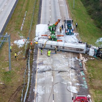
During the last tropical storm, a downed tree contributed to flooding Pleasant Avenue and the garden. Yim, the president of Pleasant Village Community Garden, watched as flooding events, once infrequent, became a more pressing issue within her neighborhood. She tried to mitigate the flooding as much as her small garden could.
“Since I became president we’ve added so much organic matter and reshaped the landscape to mitigate the flooding, but the pathway was a place that if we did get rain, it was always flooded,” said Yim.
Yim has lived in East Harlem for the last 20 years. She began gardening at Pleasant Village in 2019, right before her neighborhood felt the impacts of the pandemic. The garden provided her an opportunity to engage with her community. “I’ve always been attracted to multicultural and mixed cultures coming together in one place,” she said. “I think that also drew me in as well.”
The new pathway would be accessible under the Americans with Disabilities Act (ADA) and, in draining water to the nearby catch basins, would decrease neighborhood flooding this hurricane season.
A diamond grid underneath the loose sediment of the path increases the permeability of the walkway. The grid is made of recycled polypropylene, a type of thermoplastic with many uses including food packaging, automotive battery casings, and syringes. For drainage, the design allows water to move through the base to the low spots of the pavement.
Yim is confident the new path will drain. In the first month of summer, with only a few storms over East Harlem, the pathway consistently absorbed rainwater. Yim says they prepared for this. “We installed a fixed drain to divert any excess water that would fall into the central pathway and that gets diverted to other parts of the garden,” she said. “I’m pretty confident that we will be free. We haven’t had any issues yet but we haven’t really had any heavy rain either.”
With climate change and warming temperatures, East Harlem can expect rainfall this summer. The National Oceanic and Atmospheric Administration and the Climate Prediction Center announced that they expect 12 to 17 storms with winds of 39 mph or higher to form in the 2023 Atlantic hurricane season.
And East Harlem has faced flooding before.
A History of Flooding and Storms in New York
East Harlem, or “El Barrio,” consists of the northeastern portion of Manhattan. Many consider the streets between East 96th and East 135th Streets as neighborhood boundaries. Residents of East Harlem are primarily descendants and immigrants from Black and brown communities across the Global South.
According to Census Reporter, in 2021 NYC Manhattan Community District 11, which comprises all of East Harlem, had a population of more than 100,000. Forty-three percent of residents identify as Hispanic (of any race) and 29 percent of residents identify as Black (non-Hispanic).
Risk Factor, a company that tracks and maps climate risks across the United States, ranked East Harlem as a zone with a moderate risk of flooding. The designation means that over the next 30 years, East Harlem faces flooding that is likely to impact day-to-day life. The study found that there are 819 properties, about a third of the total in East Harlem, that have greater than a 26 percent chance of being severely affected by flooding.
There are multiple types of flooding hazards in East Harlem, according to Veronica Olivotto, a P.h.D. candidate at The New School. One is coastal storm surge, in which a hurricane comes from the Atlantic and impacts the coast. “It’s a slower impact but it needs to be factored into the modeling that we do and that’s influenced by climate change,” she said.
In 2019, as a second-year student, Olivotto used geographic information systems (GIS) to map East Harlem basement apartments in the flood zone. “There is the inland flooding, which has to do with what they call ‘blue sky’ flooding,” which occurs on sunny days with high tides, she said. “This is not necessarily triggered by a hurricane. It could be triggered by a dark cloudburst event or a lot of rainfall falling in a short amount of time that overwhelms the drainage system.”
New York’s drainage system relies heavily on a combined sewer system where stormwater and wastewater are carried through one pipe. In heavy rain events, the additional stormwater surpasses the pipe’s capacity and creates overflows.
[How Are Hurricanes Connected to Climate Change?]
“Hurricanes tend to be more of a risk for the Carolinas than New York, but we must be prepared for one-offs,” said Xavier Santiago, Community Board 11 committee chair.
Tropical Storm Irene hit New York state on August 28, 2011, a year before Hurricane Sandy. Although the U.S. Weather Bureau downgraded Irene from a hurricane to a tropical storm before it reached Long Island, many considered the storm the worst to hit New York in the last 25 years.
According to the U.S. Geological Survey’s 2011 Floods of New York study, 31 counties in the state were declared disaster areas with damages of over $1.3 billion and 10 reported deaths. Weather patterns pushed Hurricane Irene’s arrival in New York to a Saturday afternoon, sooner than the meteorologists’ original Sunday morning landfall estimation. The New York Times reported that Irene’s shift in arrival upended then-Mayor Michael Bloomberg’s evacuation plan for many low-lying areas of the city. Bloomberg took precautions such as shutting down the subway, issuing a mandatory evacuation for residents, and opening a shelter for residents seeking higher ground.
Although the storm wreaked havoc across the Northeast, the city was spared, while the New York suburbs recovered slower. But Hurricane Irene prompted New York officials to consider the impact of climate change on city life, with an eye toward low-lying neighborhoods like East Harlem.
A year later, Hurricane Sandy inundated New York in October 2012. Due to weather patterns, the storm barely missed East Harlem but still flooded other areas of Manhattan. In a city study of the impact of Hurricane Sandy, officials found that the storm significantly impacted residents in public housing. Many New York City Housing Authority (NYCHA) developments are located on coastlines and in flood zones. More than 400 NYCHA buildings with around 35,000 housing units lost power, heat, or hot water during Sandy, the study said.
“If the tides had been in, it would have been catastrophic,” said Santiago. “We only got lucky—and not from a climate-resilience point of view, but from a lucky perspective.”
Nine years after Sandy, Ida hit the city as a tropical storm in September 2021, flooding basements and the subway system and claiming 45 lives.
“I feel that [storm] was really a wake-up call for many of the officials that work on stormwater management since then,” said Olivotto.
In her book “Extreme Cities,” Ashley Dawson explores urbanization in major cities impacted by the climate crisis. “Cities, I contend, are at the forefront of the coming climate chaos, their natural vulnerabilities heightened by social injustices,” she writes.
Sandy and Ida laid bare, once again, how the impacts of the climate crisis are disproportionately felt even in places like New York, a city with what is considered progressive climate goals and policies. Dawson urges readers to reexamine the praise New York and other cities receive for their climate resiliency and planning in light of storms like Irene, Sandy, and Ida and the increasing threats faced by communities of color and low-income neighborhoods. A decade after Hurricane Sandy, The City reported that residents of East Harlem continued to wait for funding and transparency surrounding city-led resiliency projects.
“For the longest time, East Harlem has been the afterthought of Manhattan,” said Santiago.
At the “Mercy of the Tides”
As of 2023, there are state and city capital infrastructure projects that may address climate change resilience or stormwater management in East Harlem. They include a variety of new developments, including bridges, sewer systems, and parks.
In East Harlem, some of the current infrastructure plans include a city-funded initiative to stabilize and reconstruct portions of the East River Esplanade, Mayor Adam’s Cloudburst Resiliency Project that helps mitigate flooding from intense rainfall, and a $3.5 billion city-state project to improve stormwater management and protect New York Harbor through green infrastructure.
Infrastructure projects can take years to complete, and residents of East Harlem are seeking more immediate projects focused on mitigating flooding. In the fiscal year 2024 executive budget register, members of Community Board 11 requested that the New York City Department of Environmental Protection evaluate a public location for rain gardens, green streets, green playgrounds, catchment basins, rain gardens, and bioswales as means for mitigating flood risks.
The Department of Environmental Protection responded that further study was necessary. Even if the request for the project is approved, completion could still take years.
“Flood mitigation, regrettably, is not going as fast as it should,” said Santiago. “As things are now, we are at the mercy of the tides.”
Keep Environmental Journalism Alive
ICN provides award-winning climate coverage free of charge and advertising. We rely on donations from readers like you to keep going.
State and city-led capital infrastructure projects take time. “The playground in Thomas Jefferson Park took about 10 years,” Santiago said. “Fast past is seven years unless it is an emergency.”
Funding can also slow down the timeline for infrastructure projects.
“You can get partial funding for the project and the project does not go live until it’s fully funded,” Santiago said. “We’ve seen this not just with environmental projects, but with playgrounds, schools, and public housing.”
As residents await infrastructure projects, many community members, including Yim at Pleasant Village Community Garden, have created their own green infrastructure. A permeable and accessible community garden builds climate resilience by both strengthening community relationships and offering infrastructure to help drain stormwater.
“For our garden, we also installed a rain garden,” said Yim, explaining that a depression in the garden creates an area where rain will collect to help control flooding, in combination with the permeable pathway. The rain garden has been encircled with loose gravel surrounding perennials like hostas, coral bells, and rudbeckia that absorb rainwater.
“Everything that’s planted within that garden is gorgeous, survives, and thrives as well,” she said.

Juanita Gordon
Fellow
Juanita Gordon is a fellow at Inside Climate News. She graduated from Hamilton College, earning a B.A. in Geosciences with a minor in Africana Studies. After her undergraduate studies, she completed a 2022 AmeriCorps service year in New Orleans where she created visual graphics to help explain local government processes. Gordon recently graduated with her M.S. in Journalism at Columbia University where she reported on textile waste, air quality, and local environmental policies.